Remote Sensing Group.
The Earth and Planet Remote Sensing component at LERMA revolves around the microwave
radiometry from satellites. Different aspects are covered, including the analysis of satellite
observations, the modelling of radiative transfer, and the development of inversion methods.
The Earth and Planet Remote Sensing component at LERMA revolves around the microwave radiometry from satellites. Different aspects are covered, including the analysis of satellite observations, the modelling of radiative transfer, and the development of inversion methods.
A Groupement de Recherche was formed in 2008 : ‘Microwave radiometry for
the study of the atmosphere ’ (http://aramis.obspm.fr/~gdr/GDR/Home.html). It is led by our group. It strengthens the links between the French labs involved in microwave remote sensing of the Earth atmosphere. This GdR has connections in Europe and in the US and it organizes annual roundtables and workshops.
We explore two main research areas : the analysis of clear and cloudy atmospheres and the characterization of terrestrial and planetary surfaces. The aim is first to understand the physical environment and second, to accurately estimate atmospheric and surface information from satellites. The complexity of the problems to be solved has led us to develop methodologies that combine the analysis of a large variety of satellite observations at different wavelengths, along with model outputs and in situ measurements. The Earth is our primary focus, but we are also involved in the analysis of other objects of the solar system (i.e, Titan, comets), using similar observation techniques and methodologies.
A transfer of know-how has been established between the CNRS and a start-up issued from this group (Estellus see http://www.estellus.fr/). Part of the operational aspects of this activity is now performed by Estellus.
Despite limited manpower, this component benefits from a large international recognition, with strong collaboration with many labs in France (e.g., LMD, LEGOS, CESBIO, LA) in Europe (e.g., University of Kiruna, K.ln University, UK Met Office) and in the US (NASA/GISS, City College NY, AER), and active participation in a number of international projects and committees (GEWEX, ITOVS).
I - Analysis of clear, cloudy and rainy Earth atmospheres
Compared to visible and infrared satellite observations, microwaves are less sensitive to clouds and to a certain extent microwaves can probe through the clouds. Microwave satellite data up to 190 GHz are now available operationally for meteorology to provide profiles of temperature and water vapour even under cloudy conditions, but their use is still limited over land surfaces, due to the contamination of the signal by the surface radiation. Thanks to our estimation of the land surface microwave emissivity at global scale (see the land surface activity below), we developed methods of inversion of atmospheric profiles over land with microwaves, for example for the operational algorithm of the Saphir instrument on board the Indo-French Megha-Tropiques mission (Aires et al., QJRST, 2012 ; Bernardo et al., QJRMS, 2012). Our estimate of the surface contribution is also adopted for the retrieval of precipitation over land (Co-I of the Global Precipitation Mission science team). It paves the way for the use of microwave observations over land in the operational weather forecast centres.
As part of the objective to optimize the use of satellite data, the synergy of visible, infrared, and microwave observations has been rigorously quantified for the retrieval of temperature and humidity profiles over ocean (Aires et al., JGR, 2012). It showed the impact of microwaves, even under clear atmospheres. This work, initiated through an ESA contract, has been extended over land (Paul et al., JGR, 2012).
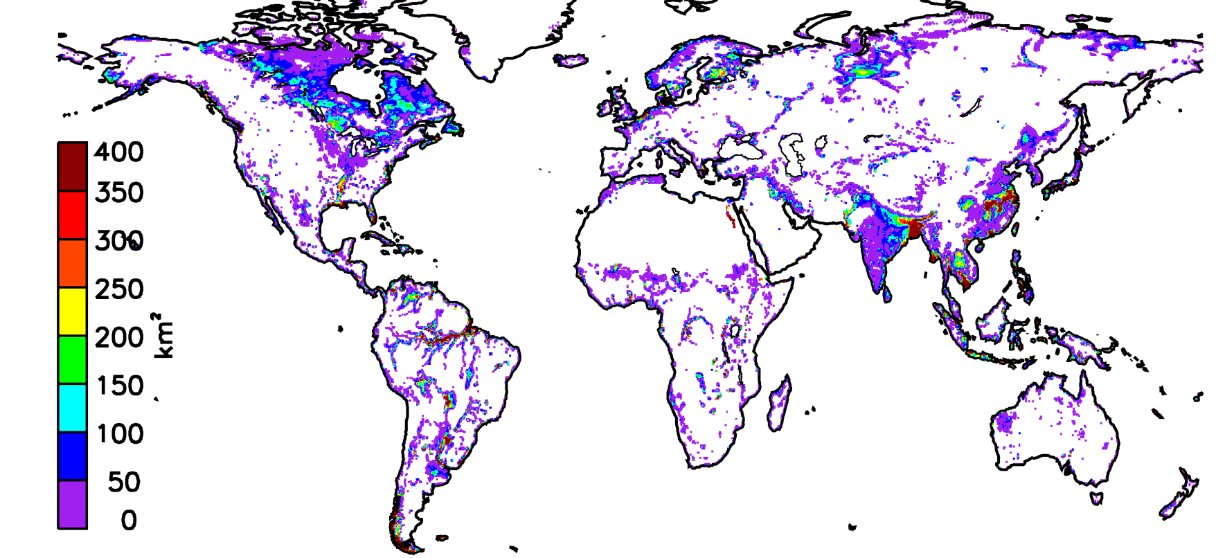
Fig.1 Titre.
Regarding cloudy atmospheres, we focused over the last years on the analysis of the ice
phase in the clouds and its quantification. The impact of ice clouds on the global Earth
energy budget is still unclear, with orders of magnitude differences in the ice cloud amounts predicted by Global Climate Models (GCMs), as well as from present satellite observations.
To reduce these problematic uncertainties, observations at millimeter and sub-millimeter
wavelengths have been suggested. Today, these measurements are not available from Earth observation satellites, and our team actively contributed to promote the development of a millimeter sub-millimeter instrumentation on board satellite. First, we carefully analyzed the sensitivity of this wavelength range to the cloud ice phase, from multi-wavelength radiative transfer calculation using state-of-the-art radiative transfer model (ATM, ARTS) coupled with realistic meso-scale cloud simulations (Meso-NH, WRF). Retrieval algorithms for both ice and liquid clouds and rain were developed, based on these simulation, to prove the interest of the millimeter sub-millimeter observation to quantify the cloud ice phase and rain (Meirold-Mautner et al., JAS, 2007 ; Mech et al., IEEE TGRS, 2007 ; Chaboureau et al., JAMC, 2007 ; Defer et al., JGR, 2008). Recently, EUMETSAT decided that the next generation of European meteorological satellite (MetOp-NG) will carry a millimeter submillimeter instrument (ICI). In order to prepare the exploration of this wavelength range, ESA supports the development of an airborne demonstration. The ISMAR (International Sub-Millimeter Airborne Radiometer) is currently built by the UK Met Office and ESA for an implementation on the UK Met Office BAe-146 aircraft (Charlton et al., 2009). Our team is involved in the definition of the instrument specifications, on the elaboration of the validation strategy of the demonstrator and on the assessment of the theoretical performances of the instrument. We work on realistic radiative transfer simulations from observational and model based atmospheric profiles at the millimeter and sub-millimeter wavelengths, concentrating now on the retrieval of snowfall, a variable that is still very difficult to measure from satellite.
We demonstrated in the past the link between the presence of graupels in convective clouds as reported from passive microwave (and sub-millimeter wave in the future) and the occurrence of lightning flashes. We were involved in a series of studies dealing with the analysis of lightning and cloud observations as recorded by ground- and space-based
instruments in order to document the electrical and microphysical properties of the convective clouds over Europe and the Tropics. In addition, in preparation to the future space-based Meteosat Third Generation (MTG) Lightning Imager (LI), our group designed a validation and verification strategy of this innovative instrument for EUMETSAT.
The expertise of the group in atmospheric analysis can serve the astronomy community. Development and operation of a cloud monitoring instrument at ALMA and/or NOEMA site have already been discussed, in collaboration with the technical group and with Pole 2, in order to improve ALMA / NOEMA operations under high cloud operation. Investigation of MIRO observations during the three Earth fly-bys of the ROSETTA spacecraft is a unique opportunity to test MIRO instrumentation. The expertise of LERMA in atmospheric retrievals helps characterize the astronomical observations, and an efficient collaboration with LESIA has been put in place. Other astronomy-atmospheric application plans the use of LOFAR for the detection and characterization of the lightning flashes in Earth thunderstorms and for an inter-operation with the up-coming Meteosat Third Generation Lightning Imager (MTG-LI, optical sensor), designed to monitor in real time the lightning activity from Earth geostationary orbit.
II - Multi-satellite estimations of Earth surface parameters and their analysis
Our activity on the continental land surfaces is initially based on passive microwave satellite observations. We calculated microwave emissivities directly from satellite observations, with the help of auxiliary data to remove the contribution of the atmosphere and the modulation signal by the temperature of the surface. Microwave emissivity atlases have ben produced, on a monthly basis, over 15 years. They are distributed to the community and used in a large number of institutions, internationally. A land surface microwave emissivity parameterization (TELSEM for Tool to Estimate the Land Surface Emissivities at Microwaves) is based on this data set and this software is now distributed with the European community radiative transfer model (RTTOV) (Prigent et al., IEEE, 2008 ; Aires et al., QJRMS, 2011). Once these emissivities are calculated, they can be used for a large variety of applications. First, by inversion of microwave observations over land, surface skin temperatures can be estimated, regardless of cloud cover. A long time record of land surface temperature from microwaves has been produced and evaluated (Catherinot et al., JGR, 2011). This complements the infrared observations that are blocked by clouds. Second, with a good knowledge of the land surface contribution, the atmospheric properties, even close to the surface, can be extracted from the satellite observations as described above.
Finally, these emissivities are sensitive to a large range of surface properties (soil moisture, standing water, vegetation, snow…), and as a consequence, they can help provide information on these parameters, potentially combined with other satellite observations with complementary sensitivities. We developed methods to take advantage of the synergy between the different satellite observations, and we applied it to the estimation of various surface properties. We produced a global estimate of wetland extent for the last 15 years.
The analysis of this dataset showed that the wetland extent has decreased, and the
population pressure on these sensitive areas has been evidenced (Papa et al., JGR, 2010 ; Prigent et al., GRL, 2012). This dataset has been distributed to more than 40 institutions around the world. The wetlands are a major source of atmospheric methane, a very powerful greenhouse gases, and our dataset is a unique information for the modelling of methane emissions (e.g., Ringeval et al., GBC, 2010 ; Petrescu et al., GBC, 2010 ; Hodson et al., GRL, 2011). It also helps evaluate hydrological modeling (Decharme et al., JGR ; 2008, JC, 2011), or is used for the estimation of river water storage (Frappart et al., JGR, 2008 ; HESS, 2010).
Using a combination of satellite observations and land surface model outputs, latent and
sensible fluxes over land have been estimated (Jimenez et al., JGR, 2010). Our group
significantly contributed to the GEWEX LandFlux activity and co-led the international
LandFlux inter-comparison (Jimenez et al., JGR, 2011 ; Mueller et al., GRL, 2012). We also produce soil moisture estimates at global scale from combined
satellite observations, including passive and active microwaves and thermal infrared. Other activities included the evaluation of infrared derived surface temperature, a key variable for the radiative budget of the planet that is still subject to significant errors (Jimenez et al., JGR, 2012). We contribute to a better understanding and estimate of the IR land surface emissivity (Jimenez et al., JGR, 2010 ; Paul et al., JGR, 2012), in order to improve the surface skin estimation from infrared observations and the retrieval of atmospheric parameters in the low atmosphere from surface-sensitive infrared channels.
The launch of the SMOS (Soil Moisture and Ocean Salinity) satellite (interferometer at 1.4GHz) provides the community with the first observations directly dedicated to the soil moisture. Our group analyzes the new data and combines them with the other available satellite observations for an improved hydrological characterization of the land surface. We are also involved in the NASA/CNES SWOT (Surface Water and Ocean Topography) mission and we will invest in the preparation of the analysis of these observations, thanks to the expertise we acquired in the wetland detection and characterization. We
belong to the Science Advisory Group of the French-German MERLIN satellite project (phase B at CNES), to provide this community with land surface information to optimize the retrieval of methane concentration.
Note that our general expertise in the retrieval of surface parameters from multi-satellite observations also led to fruitful collaboration with oceanographers, for the retrieval of sea surface wind speed (Quilfen et al. JGR, 2007) and for the preparation of a future ESA satellite missions for the retrieval of sea surface temperature. We work very actively on the retrieval of a large number of surface parameters from multisatellite observations. Our products (some of them unique) are distributed to a wide international community and we are part of international committees (GEWEX, ITOV) and numerous projects (CNES, ESA, NASA, NOAA) related to these activities.
III - Analysis of planetary observations
The Cassini mission orbits around Saturn since 2004, and flies by Titan every 3 weeks.
Analysis of Titan surface combines Cassini microwave observations in passive and active
modes. The presence of dunes on Titan has been evidenced, with distribution related to the latitude and terrain altitude (Le Gall et al., Icarus, 2012) as well as young craters. Lake and seas of liquid ethane and methane were also discovered, and their behaviours are still under investigation. These spectacular results have also generated article in the international press, as well as TV shows. These studies are performed in collaboration with JPL, Bordeaux Observatory, Paris VII, and IPGP.
The ESA Rosetta mission will complete the most detailed study of comets ever attempted. It carries two microwave instruments : MIRO and CONSERT. In order to analyze the asteroid observations (Steins and Lutetia) and to prepare the analysis of these observations, measurements of dielectric properties of porous granular materials and meteorites have been undertaken on a large range of frequencies encompassing those of MIRO and CONSERT.